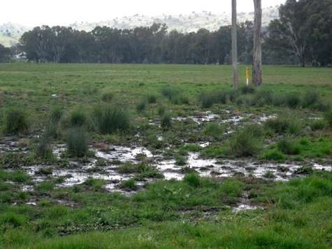
 Dryland salinity is one of the important issues facing landholders in Central West NSW. Each salinity-affected site has different characteristics and there is a need for site specific information to plan and/or apply appropriate treatments.
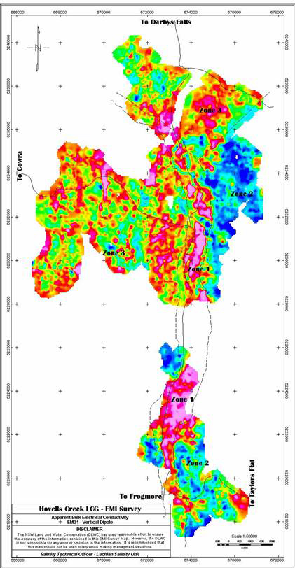
An Electro-magnetic Induction (EMI) survey coupled with validation is one method to obtain site-specific data. The survey was undertaken by DLWC-Cowra based staff for the Hovells Creek Landcare Group with funding support from the ‘Salt Action’ program (NSW government).
The aim of the investigation was to map and identify wet and possibly saline areas. When compared to the surrounding landscape of the Hovells Creek Landcare Group, the EMI survey can be used to define how large and severe a current saline site is, it’s potential spread and where possible future saline areas might occur.
The EMI survey was carried out on properties within the Hovells Creek Landcare Group focusing mainly on saline hazards. Salinity is evident in the Hovell’s Creek Landcare Group properties and the properties surrounding the group.
The Hovells Creek LCG area was split into three main zones, these consist of:
Zone 1 – Hovells Creek River Flats
Transported sands and clays, prone to flooding and waterlogging. Highly saline areas exist within the zone. These areas need immediate attention (saline agronomy) to include them into current production, with the surrounding area needing tailored landuse changes to increase water use and productivity.
Zone 2 – Slightly Weathered Granite
Rocky outcrops and hill slopes with large exposed boulders. Waterlogging areas occur at the break of hill slopes. These are mainly to the east of the Survey area. These areas need to be managed to utilise water more efficiently to help decrease groundwater recharge.
Zone 3 – Moderately Weathered Granite
Rocky outcrops to the South and West of the survey area, prone to perennial slightly brackish springs that occur right up to the top of sub-catchments. These areas need to be managed similar to Zone 2 areas with more focus on the utilising the springs as a water source.
Download: The survey report (750kb)